There can be few Civic Society members who do not possess some Ordnance Survey (OS) maps. Perhaps they are 1:50,000 Landranger sheets, in magenta covers, or 1:25,000 Explorer sheets clad in tasteful orange. Many members will still have One-inch maps from the good old days. Whether used regularly, or kept as reminders of past "staycations", the local sheets are just the latest in a long line of Ordnance Survey maps of Lichfield and the surrounding area. So, when and how did the story begin?
Although it had no formal start date the Ordnance Survey is generally agreed to have begun its work in 1791. As so often in the past there were fears of a French invasion on the south-east coast and up to date and accurate mapping at 1:63,360 (one inch to a mile) was needed. The first map was published in 1801 and the Survey's task was soon extended to cover the whole of Great Britain.
Generally working northwards and westwards, the surveyors arrived in our part of Staffordshire in 1815. Two years later a drawing at two inches to the mile had been completed. This would then be reduced to one inch to the mile and engraved onto copper sheets to form the final map for publication. Normally this process would take another couple of years; but Lichfield had to wait far longer as in the 1820s much of the Survey's resources were diverted to mapping the island of Ireland, where there was an urgent need for an accurate survey for taxation and to clarify land ownership.
Work on what became sheet 62 of the One-inch map eventually resumed in about 1831. During the intervening 15 years there had been little change in Lichfield, but rapid development in Birmingham and the Black Country meant a lot of extra work for the surveyors.
Almost 20 years after the local survey had first commenced sheet 62 was finally published, in four quarters, on the 9th of January 1834. Lichfield was in the north-east quarter and, although the complete map also covered Birmingham, Wolverhampton and the Black Country, the whole sheet was entitled Lichfield - the Ordnance Survey preferred to use the names of historic towns and cities instead of those of upstart centres of the industrial revolution!
Sheet 62, of what later became known as the Old Series, was the only OS map of Lichfield for half a century and its One-inch map for nearly 60 years. During that time it was printed at least 21 times; but many of the reprints had only cosmetic changes (such as the price going up or down) and only twice were developments added in and around Lichfield.
The South Staffordshire Railway (with stations at City and Trent Valley) and the London and North Western Railway (with a station at Trent Valley on what is now the West Coast main line) were both built and opened in the late 1840s. These were soon plotted and added to sheet 62 (the Ordnance Survey almost always did their own surveys of railways as they did not trust railway company plans). While in Lichfield they also surveyed other developments. The new Walsall Road (by-passing Christchurch Lane) and Trent Valley Road (replacing Burton Old Road as the main route to Streethay) had both opened in 1834; just too late to be included on the map when first published. Also added was the "Union House" on Trent Valley Road (the Union Workhouse, later St. Michael's Hospital, which had opened in 1841). However, there was no attempt to add any more new buildings or to reflect other changes that had taken place since the original survey.
By the 1860s the earliest One-inch maps of southern England had become seriously out of date. After the inevitable wrangling with the Treasury over funding work on a New Series of One-inch maps began in about 1870 - again in the south-east of England.
The surveyors were back in south Staffordshire in 1881 and 1882 to work on what was to become sheet 154; entitled Lichfield. As before some portions took longer to complete and the map was not published until 1892 - even though the New Series sheets covered much smaller areas than their predecessors. In the meantime; the railway from Lichfield City station to Sutton Coldfield via Shenstone had opened in 1884 and was added to the last printings of the Old Series sheet.
The new survey was much more detailed than the first and spawned a whole series of larger scale maps and plans. 1884 saw the publication of maps of Lichfield and district at the scale of 1:10,560 (about six inches to one mile) and plans at 1:2,500 (about 25 inches to one mile). The built-up area of the city was also published on nine large sheets at a scale of 1:500 (over ten feet to one mile). These showed every individual building and feature in detail. So, map-wise, Lichfield suddenly went from famine to feast. Since then, although publication of the 1:500 plans was not repeated, the city and surrounding areas have generally been well portrayed at a range of scales that meet most map users' needs.
William Henwood
March 2021
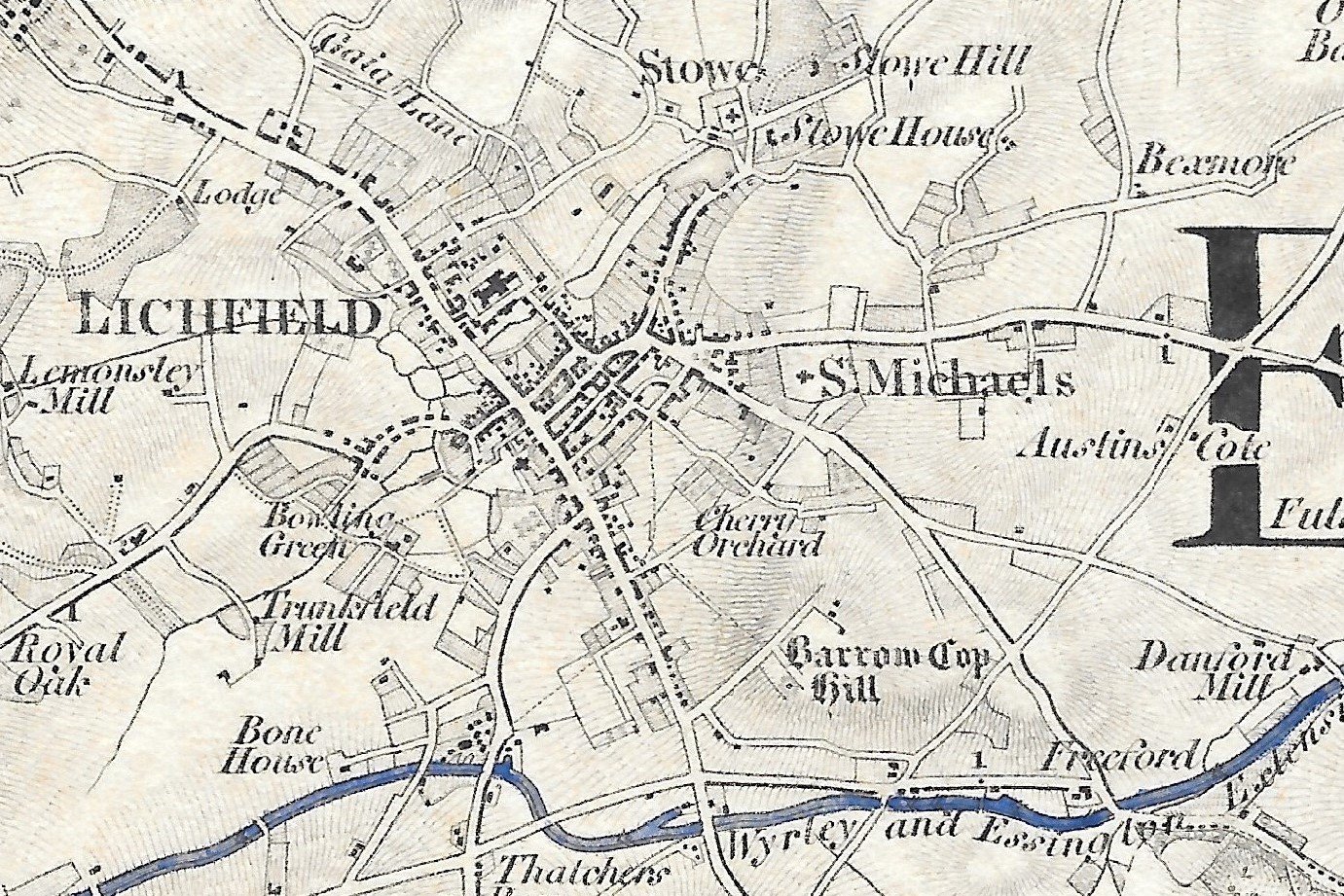
Extract from the One-inch map, sheet 62, published
in 1834 with the canal coloured by hand.